Read Italiano version
Situated in the Commune of Alia, it is considered to be one of the most important archaeological sites in Sicily.
Presenting an interview by Anna Casisa with Prof. Carmelo Montagna, on the extraordinary Gurfa Caves. A mighty, rock structure testifying to the ancient civilization in Sicily. A destination for imminent scholars and taking pride of place in Archaeological Tourism in the Province of Palermo.
They are called Grotte della Gurfa, yet they are not caves, not even granaries, stalls or ancient storehouses, at least not in their original use. They are certainly of Arab origins in their topography, however, there are numerous doubts over the meaning of their name: pit, sloped mountain wall or even chamber on the upper floors. There are even doubts over the sites attribution and dating. Yet, notwithstanding all these doubts, there are those who consider the Grotte della Gurfa architecture on a grand scale, impregnated with archaic sacredness for their sheer dimensions. A sanctuary or perhaps, even the tomb of King Minos of Crete, who arrived in Sicily to capture Daedalus. In the explanation given by the Art Historian, Carmelo Montagna who in his books (Sulle tracce di Minosse, Thòlos e Tridente, Il Tesoro di Minos) has tried to disclose the millenary secrets of this mysterious structure. A fascinating, even convincing interpretation emerges from the studies by its author. Furthermore, charm is not lacking in this place that the film director Giuseppe Tornatore chose as the setting for some of the scenes in his film LUomo delle Stelle.
By Anna Casisa
Professor Montagna, what possible historical evidence could be hidden in the cavities of this ancient stone monument?
In the first place, the grand monumentality of these hypogea, in particular, the bell shaped chamber like a thòlos whose dimensions make it the largest in the Mediterranean. The generic definition of grotto is inappropriate and misleading, seeing that we are talking about true architecture, even though it was built by excavating; a true environmental sculpture made by subtraction as Michelangelo Buonarrotti would have said. From the observations made and the data taken from my research on the architectural, cultural matrix that orientated the sophisticated designer/builder which would lead us to the Bronze Age in the heart of Sikania, with its Minoan-Mycenaean co-ordinates and the inevitable successive contaminations, to a place where everyone has passed through.
What have previous studies uncovered?
Amidst light and shade, certainty and mystery, the most ancient testimony on site is the small kiln shaped tombs excavated into the third level of the rock face, typical of the so called Castellucciana civilization in Sicily, dating back to the Bronze Age (Aeneolithic IV-III centuries BC).
Briefly, this is the history of the studies carried out previous to my work on Gurfa:
-
according to the bibliographic sources of the Superintendence, which I have not been able to verify and seem to have been contested by G. Mannino, it is generically attributed to the Pelasgians by P. Orsi;
-
is considered to be a Bronze Age settlement, connected to the presence of a Necropolis on its rocky summit, by G. Cumbo;
-
is compared to the Mycenaean burial chambers, in the example of the famous Atreus Treasure of Mycenae by B. Rocco;
-
S. Braida closely links it to the large hypogea of Hal Saflieni in Malta, belonging to the Megalithic culture;
-
is classified as a settlement from the Late Roman, Byzantine or generically, to the Late Middle-Ages, as a granary pit, by various scholars and therefore defined as Saracen according to popular tradition; also due to its Arab name, which gives us nothing to go on with regards to the origins of this complex, but does testify to it having had a specific Islamic use, between the Muslim conquest of the island and the period of Frederic II.
The Gurfa is quoted as having been a populated and flourishing Arab farmstead, data that already existed in 1150, when King William gave it to the Spedale dei Lebbrosi in Palermo. Later, the farmstead became part of the Teutonic Order to whom the Spedale dei Lebbrosi was given, together with all of its patrimony. Its more recent history has become entangled with the Sicilian farmer landowners.
Could you describe the structure?
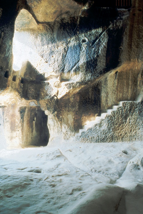
They are artificial rock structures, excavated by man in the imposing sandstone rock face. The structure is made up of a large bell-shaped chamber (Thòlos ) lit from on high by an oculus (like the Pantheon in Rome) and with a large curtain room on the ground floor, connected by corridors, stairs, cisterns, a descending well, walkways, four rooms upstairs and various small spaces probably destined for funerary use on the summit of the slope. Yet, there are other structures nearby, such as a perennial spring (the Cuba), a large external megalithic menhir behind the entrance of the hypogea, a triangular bath (for ritual ablutions?), a triangular cavity-sanctuary in the valley with clear signs of Megalithism and what remains of a small idol (a bullock?), a thòlos tomb, officially identified as such by the archaeologist, Tomasello, was found about 20 metres from the bell-shaped space (Thòlos ), the largest in the Mediterranean (still awaiting official archaeological recognition ).
A hypogean structure, covered originally in wood panelling that would have been tinted and decorated at times, with thick layers of tar, impregnated smoke deposits on its walls, a sure sign of there having been a terrible, destructive fire. What we see today is therefore the skeleton, a negative of the edifice, of an excavated intervention aimed at building a planned, complex settlement in ancient times. Both the interior and exterior wooden walls are missing (which would have been there seeing that there are still the remains of fitted sections). Paradoxically, the archaeological surface remains are missing, due to the uninterrupted multi-millennial use of the site as dwellings and for agriculture by landowners, up to about the end of the last century.
What are your hypotheses on the use of these spaces?
In going into the first room of the ground floor, the curtain roof, in other words, a layered roof catches the visitors attention. It is a room, used as a stable at the end of the last century, with double rows of troughs excavated into the wall. In my opinion, it was originally a dynastic funerary tomb. It was not a tomb for one, single person, but for a group of people to whom each space was assigned (on the wall 6+6 spaces are still visible on the shelves of the funerary surfaces, transformed into troughs). The four sided niches in the centre of the northern wall in front of the entrance (there might have been the remains and the sacred emblems of the person / head of the family, the most important founder) and the holes on the side walls (which revealed the social standing of the people closest to the leader of the group), together with the apparent uselessness of the purpose of the double-strata covering, in a room with stone ceiling, reminds us of a residence for the afterlife, as for instance, in the great Etruscan funerary architecture which is however far more recent (VII century BC. For instance the Tomb of the Lionesses in Tarquinia). There is an oculus in the roof which was accessible originally from what remains of the fitted section of a wooden gallery, which via a well connects the room to the upper floor. This perforation, according to my interpretation, was probably used for a ritual which can be found in ancient literature (e.g. Homer in Odyssey XIX, 178-9) known as Catabasi.
As a matter of fact, the one who would have had to exercise absolute power over the community was lowered down into a crypt and had to remain there for some time: it was a macabre rite which was repeated in the world of Minoan-Mycenaean Crete every nine years (it is the Homeric ennead Minos). This ritual imbued a man with all of the divine qualities in order to reign, then, after an incubation period he would become a Minos, that is a king who can be likened to a deity, having the power of life and death over his subjects.
The second space has an oval layout and is bell-shaped with an oculus of light in the ceiling, it is the largest thòlos in the Mediterranean (c.16m x 13m), as far as I am concerned. Such dimensions and its suggestive effect evoke the idea of a place used as a temple and worship in the tradition of the Minoan-Mycenaean culture (e.g. the Treasure of Atreus in Mycenae, XV century BC). I am not certain how this rock was excavated.
There are three levels of visible cavities on the walls in the thòlos sector, behind the entrance, which were clearly used to support some wooden lofts formally used by onlookers for particular rites or events ( during the mediaeval and rural ages they became mezzanine floors for dwellings).
The bell-shaped chamber would not have any significance as a dwelling place, but would as a religious one due to the existence of the nadir pit in the centre of the floor (symbol of the axis / the world axis, because of its association with the hole of the zenith), and to some traces of platforms removed from the circular perimeter, as well as, the presence of a recessed apse facing the eastern wall.
I have also been able to verify that the arrival of the spring equinox on 21 28th March, coincides with a suggestive ray of light which illuminates the nadir floor pit at 12 oclock, summer time. Its design – due to its symbolism and remarkable dimensions – brings to mind the worshipping of deities, linked to a world hovering between light and darkness, life and death, like the worshipping of the great Mediterranean Mother, Aphrodite, as well as, the commissioners, builders and the rituality of a sophisticated tradition.
A significant curiosity is a similar thòlos, with its perforated ceiling and of modest dimensions when compared to ours, connected to a sacred well for the cult of water, that can be found in nuragica Sardinia dating back to the Bronze age: it is the holy well of Saint Christina in Paulilatino (Oristano), where the phenomenon of the moon in the well can be seen once every nine years. Just like the sun/moon phenomenon which occurs at Gurfa during a determined cycle (called Metonic for the moon) that was probably used to measure how long the command of Minos would have lasted
Climbing up to the 1st floor, with its various engravings and graffiti on the external walls dating back to the conquering of the South at the same time as the Unification of Italy, you get to the small corridor leading to the Palace. On the left, the smallest chamber has the feature of only being able to be closed from the inside: this was probably the room for the real treasure of the Sanctuary of Minos, where the votive offerings would have been deposited and guarded from the inside. The second room, the largest and highest, would have been panelled like all of the others. To the right of the entrance there is a fireplace, while on the left, strangely suspended two meters from the ground, a womb shaped space, connected by a hole in its summit to the water cistern overhead. In my hypothesis of attribution, this would have been the most important chamber in the Palace, where Minos would have exercised his command, the Megaron in the Minoan-Mycenaean Sanctuary, hence that womb shaped space is unnerving and is where the incubation rite took place, during which a person, destined to become Minos/King was regressed to the pre-birth larval, uterine state, for a glorious re-birth, having survived the obscure Kingdom of Hell that was carried out by the Descent / Catabasi into the vertical well in the room next to the funerary room below, every nine years in the Minoan civilization. It is significant that a cross which is likely to be Byzantine, is engraved just below this space.
In the following room, which is the most damaged by successive inappropriate use, can be seen the well in which were lowered those who were subjected to the Catabasi-Incubation rite, as referred to previously. Decisive in being able to exclude other uses of the hole linked to its future use by farmers (e.g. for lowering hay into the stalls below ), is the obvious consideration from the legible marks of the missing trap-door that the stone that must have once closed it would have weighed around 800kg! Therefore, this makes me think that that door would have only been opened every now and again (probably once every nine years, as suggested by Homer, for the Minoan ritual of Catabasi in Crete). There is an intriguing drawing engraved in the stone behind the Catabasi well: it has been damaged by more recent engravings, however, a 60cm. square can still be clearly seen marked with six semi-circles that are wider than 10cm in diameter each.
Upon reflection, this geometry has something to do with a measuring system that can be found in all of the chambers in the thòlos tombs in the Valley of Platani, identified by Francesco Tomasello (the thòlos tombs of central-southern Sicily): a metric module, base of 6, with multiples and sub-multiples, equal to a 30 cm foot, were included in the planning of the Gurfa. The next room, the fourth, was probably the private room of King Minos and was directly connected to the facing temple chamber for worship and the responses of the oracle for visitors, according to the liturgy and rituals connected to the Equinoxes and Solstices.
You are convinced that this is the work of a professional, why?
The only certainty that I have found of the intervention of a highly educated planner/builder was in the use of Golden Ratio geometric models in the architectural planning. Its builder shows his knowledge of the house-tomb designs of the Cypriot Thòlos at Choirktia and of the wooden Anatolian-Phrygian Megaron of Gordion. Added to this, the Thòlos of the Gurfa is the largest in the Mediterranean, having unique, original symbolic features compared to the Thòlos of Atreus in Mycenae. You have to think of an artistic attribution due to its manufacture, the architectural knowledge of a builder who in the entire Platani Valley and in similar Sicilian habitats, could be attributed to a school of architects and builders that can be legitimately linked to Daedalus. I am convinced that it is the work of one of the greatest and most ancient artists/builders in the Mediterranean, perhaps the greatest architect of Sicilian Prehistory. He should probably be identified with the same mythological figure of Daidaleos-Daedalus, who built the tombs for the mythological figures of Minos-Minosse in Sikania.
I am still carrying out research on this.
Due to its design and dimensions, you are associating the Thòlos at Gurfa with the tomb of Agamemnon and the one at Minos, mythical ancestor of the Mini. The Gurfa is therefore, probably the Treasure in Sikania, the tomb of Minos?
Due to the cultural, historical, mythological and archaeological clues in the vicinity of the Gurfa obviously needing to be verified with an archaeological dig, and for what has been said so far, it has made me think of the hypogea-thòlos as the tomb-temple of King Minos in the valley of the river Halykos/Platani in Sikania, of which we have a summary description from historical sources (in particular, Erodoto VII, 170 and Diodoro Siculo IV,78). This character is the Sovreign / Minos of Crete who arrived on the coast of Agrigento on the trail of Daedalus, who had escaped from the Knossos labyrinth to Sikania, according to the famous saga of the Minotaur. Minos died (betrayed and killed in the bath) at the court of King Sicano Kokalos and was buried in a monumental temple-tomb dedicated to the cult of Aphrodite and the very same Minos who had been made into a god.
Ancient historians dated these events as being three generations before the Troyan Wars, while more reliable sources date them as being between 1334 BC and 1136 BC. Yet again, according to these ancient sources on the tomb-temple destroyed by the tyrant, Agrigento Terone in 480 BC which he had found, almost a thousand years after its being built, while sailing up the Platani river going to war at Himera. From then on, it had never been identified. It is important to bear in mind that the fluvial system, with the Gurfa being a sort of water dividing wall between its Tyrrhenian side and the Sicilian Channel off Agrigento, was almost entirely navigable and had therefore always been the route for the penetration of the hinterland from the two Sicilian coasts.
Was it you who discovered the Trident? What does this symbol mean?
Next to the entrance to the Thòlos, fortunately covered by vegetation which paradoxically saved it from being washed away, I discovered, an upside down trident, deeply engraved into the rock (c. 21 x 30cm.), together with the Christian inscription IHS (attributable to the Christian conquest by the Teutonic Knights of an Islamic site). It must be the mirror image of a metal (bronze?) base-relief removed, at some later date that symbolizes without a doubt Neptune/Poseidon, the god of the sea and king of the Minoan-Mycenaean pantheon. These symbols were engraved into the rock by mariners who had arrived safely in the area despite all the risks and the fatigue of their journey, as a reminder of their cult. Furthermore, G. Castellana found proof on the Agrigentine coastline at the site of Monte Grande, that in XVIII century BC, salt and sulphur traders/mariners passed through the Platani Valley (Halikos = the Salt Road), both the salt and sulphur came from open mines and were the petrol of ancient times.
If your studies were to be confirmed, thinking in terms of development and growth of tourism in the area, could we define the Gurfa Caves an open air treasure waiting to be discovered yet again?
In the absence of an official archaeological dig, the evident traces of destruction and fire that had burnt the wooden panelling at Gurfa are waiting to be dated. It is evident just what this specialist site, in the realms of ancient Architectural History and Archaeology, could represent for the economic and tourist development to the poor hinterland of Sicily.